Global Land Cover
Short description
Global Land Cover products at 100 m resolution are delivered annually by
the global component of the Copernicus Land Service. The most recent collection 3 (version 3.0.1) of 100 m Land Cover products for the years 2015 - 2019 were generated from the PROBA-V 100 m and 300 m satellite observations and several other ancillary datasets with global coverage. As from 2020, (2019-conso and 2020-nrt products) are planned to be generated from the combination of Sentinel-1 and Sentinel-2 satellite observations following end of PROBA-V operations. These Land Cover products provide a main discrete land cover classification map according to UN-FAO Land Cover Classification System
LCCS. Additional continuous fractional layers for all basic land cover classes which give the percentage of a 100 m pixel that is filled with a specific land cover class, are also included in the Land Cover products to provide more detailed information on each land cover class.
Update frequency
A new product is generated annually using an 'epoch', where an epoch consists of 3 years input data (one year before and one year after the reference year) in three processing modes.
- base maps for epoch 2015, that serves as reference for the classifier and regression models,
- consolidated maps (2016, 2017, 2018) one year before and one year after the reference year
- near-real time maps (2019) with one year before and only three months data of the reference year.
See
Product User Manual for more details on the procesing modes.
Temporal availability
The following epochs are available:
| Epoch year |
Product generation mode |
| 2015 |
base |
| 2016 |
consolidated |
| 2017 |
consolidated |
| 2018 |
consolidated |
| 2019 |
near real time |
The available bands include: a main discrete classification with 23 classes aligned with UN-FAO's Land Cover Classification System, a discrete classification probability map, fractional cover maps for the 10 main classes, a forest type layer, quality layer on input data density and on the confidence of the detected land cover change (only delivered for maps produced in conso or nrt mode)
Reference:
Product User ManualTable 1: Bands
| Name |
Units |
Values |
Description |
| Discrete_Classification_map |
|
0 - 200 |
main discrete land cover classification according to FAO LCCS scheme |
| Discrete_Classification_proba |
% |
0 - 100 |
Classification probability, a quality indicator for the discrete classification |
| Forest_Type_layer |
|
0 - 5 |
Forest type for all pixels where tree cover fraction is bigger than 1 % |
| Bare_CoverFraction_layer |
% |
0 - 100 |
Fractional cover (%) for the bare and sparse vegetation class |
| Crops_CoverFraction_layer |
% |
0 - 100 |
Fractional cover (%) for the cropland class |
| Grass_CoverFraction_layer |
% |
0 - 100 |
Fractional cover (%) for the herbaceous vegetation class |
| MossLichen_CoverFraction_layer |
% |
0 - 100 |
Fractional cover (%) for the moss & lichen class |
| Shrub_CoverFraction_layer |
% |
0 - 100 |
Fractional cover (%) for the shrubland class |
| Snow_CoverFraction_layer |
% |
0 - 100 |
Fractional cover (%) for the snow & ice class |
| Tree_CoverFraction_layer |
% |
0 - 100 |
Fractional cover (%) for the forest class |
| BuiltUp_CoverFraction_layer |
% |
0 - 100 |
Fractional cover (%) for the built-up class |
| PermanentWater_CoverFraction_layer |
% |
0 - 100 |
Fractional cover (%) for the permanent inland water bodies class |
| SeasonalWater_CoverFraction_layer |
% |
0 - 100 |
Fractional cover (%) for the seasonal inland water bodies class |
| DataDensityIndicator |
|
0 - 100 |
Data density indicator showing quality of the EO input data (0 = bad, 100 = perfect data) |
| Change_Confidence_layer |
|
0 - 3 |
Quality layer regarding the change detection of the current mapped year to the previous mapped year. It is a 3 level confidence mask for all CONSO and NRT maps with value definitions as:
- 0 = No change.
- 1 - Potential confidence.
- 2 - Medium confidence.
- 3 = High confidence.
NOTE: The values of Change_Confidence_layer band in 2015 data are not shown correctly, therefore this band in 2015 data should not be used.
|
Table 2: Discrete_Classsification_map classes A visualisation script can be found in our
custom scripts repository.
| Value |
Color |
Color Code |
Label |
| 0 |
|
0x282828 |
No input data available |
| 20 |
|
0xffbb22 |
Shrubs |
| 30 |
|
0xffff4c |
Herbaceous vegetation |
| 40 |
|
0xf096ff |
Cultivated and managed vegetation/agriculture (cropland) |
| 50 |
|
0xfa0000 |
Urban / built up |
| 60 |
|
0xb4b4b4 |
Bare / sparse vegetation |
| 70 |
|
0xf0f0f0 |
Snow and Ice |
| 80 |
|
0x0032c8 |
Permanent water bodies |
| 90 |
|
0x0096a0 |
Herbaceous wetland |
| 100 |
|
0xfae6a0 |
Moss and lichen |
| 111 |
|
0x58481f |
Closed forest, evergreen needle leaf |
| 112 |
|
0x009900 |
Closed forest, evergreen, broad leaf |
| 113 |
|
0x70663e |
Closed forest, deciduous needle leaf |
| 114 |
|
0x00cc00 |
Closed forest, deciduous broad leaf |
| 115 |
|
0x4e751f |
Closed forest, mixed |
| 116 |
|
0x007800 |
Closed forest, unknown |
| 121 |
|
0x666000 |
Open forest, evergreen needle leaf |
| 122 |
|
0x8db400 |
Open forest, evergreen broad leaf |
| 123 |
|
0x8d7400 |
Open forest, deciduous needle leaf |
| 124 |
|
0xa0dc00 |
Open forest, deciduous broad leaf |
| 125 |
|
0x929900 |
Open forest, mixed |
| 126 |
|
0x648c00 |
Open forest, unknown |
| 200 |
|
0x000080 |
Open sea |
| 255 |
|
|
No data |
Table 3: Forest_Type_Layer classes
| Value |
Label |
| 0 |
Unknown, doesn’t match any of the other types |
| 1 |
Evergreen needle leaf |
| 2 |
Evergreen broad leaf |
| 3 |
Deciduous needle leaf |
| 4 |
Deciduous broad leaf |
| 5 |
Mix of forest type |
| 255 |
No data |
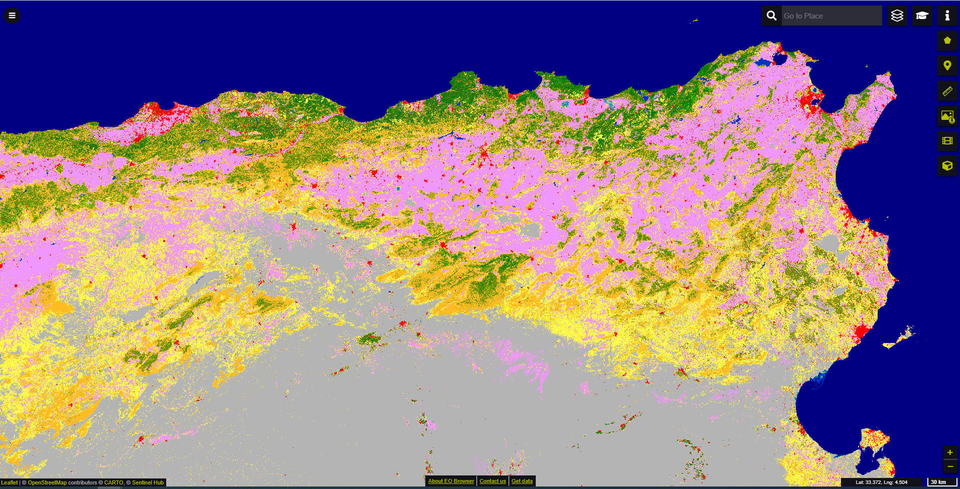 2019 nrt discrete land cover classification map for parts of North Africa visualised in EO browser
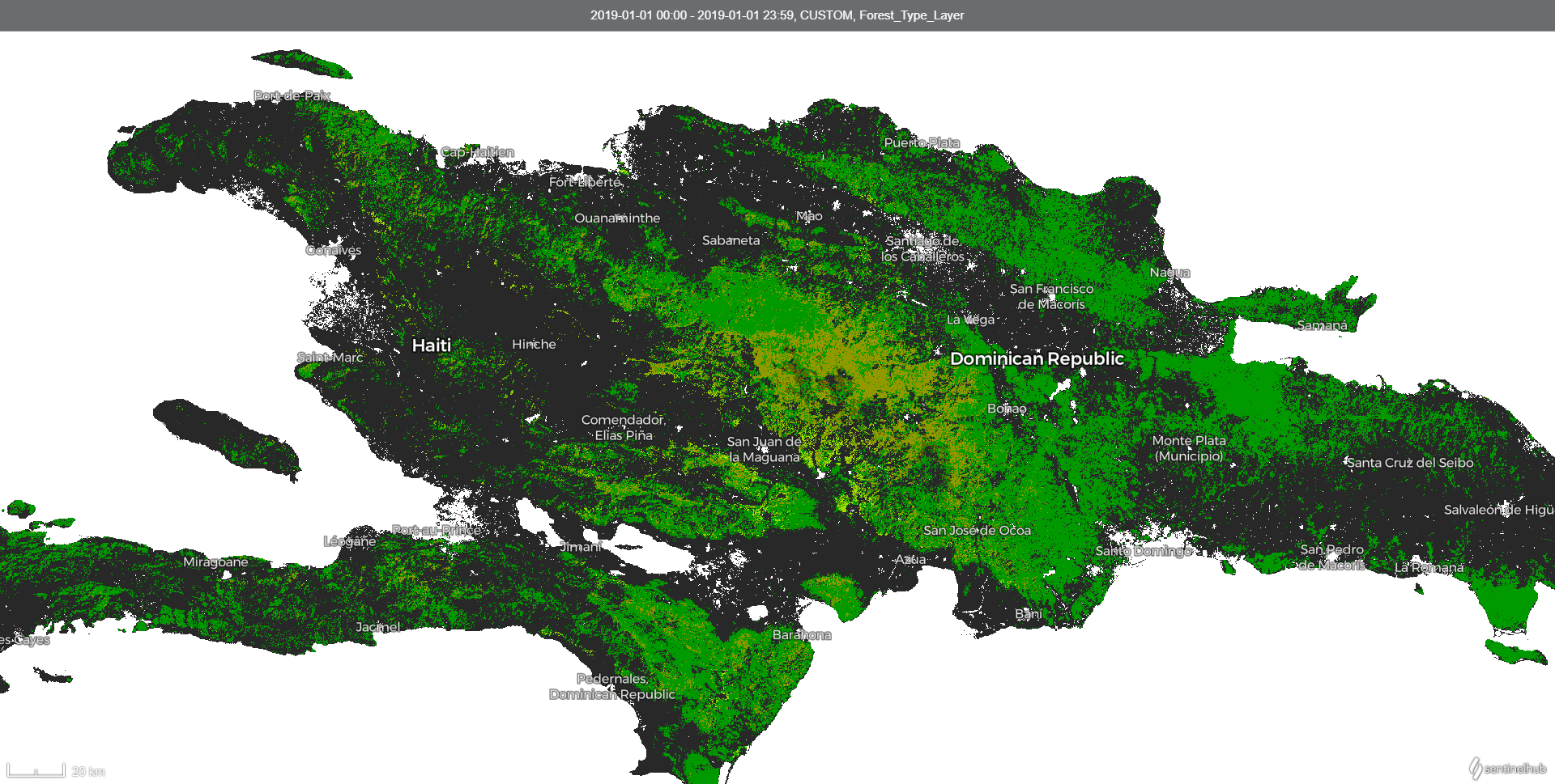 2019 nrt forest type Map over Dominican Republic and Haiti visualised in EO browser